By Reedy's Rigs · Port Phillip Bay & Western Port · Free

The free fishing app for our bays.

Built for Port Phillip Bay and Western Port. Catch diary, virtual comps, fish records, live weather and bay maps. Pre-loaded starter spots so you can fish day one. Every fish you log makes you a better fisho. Free to use.

What's inside

What BayCast actually does

Plain English, no marketing speak. Every feature exists because a real angler — one of the 70,000+ following Reedy's Rigs — asked for it.

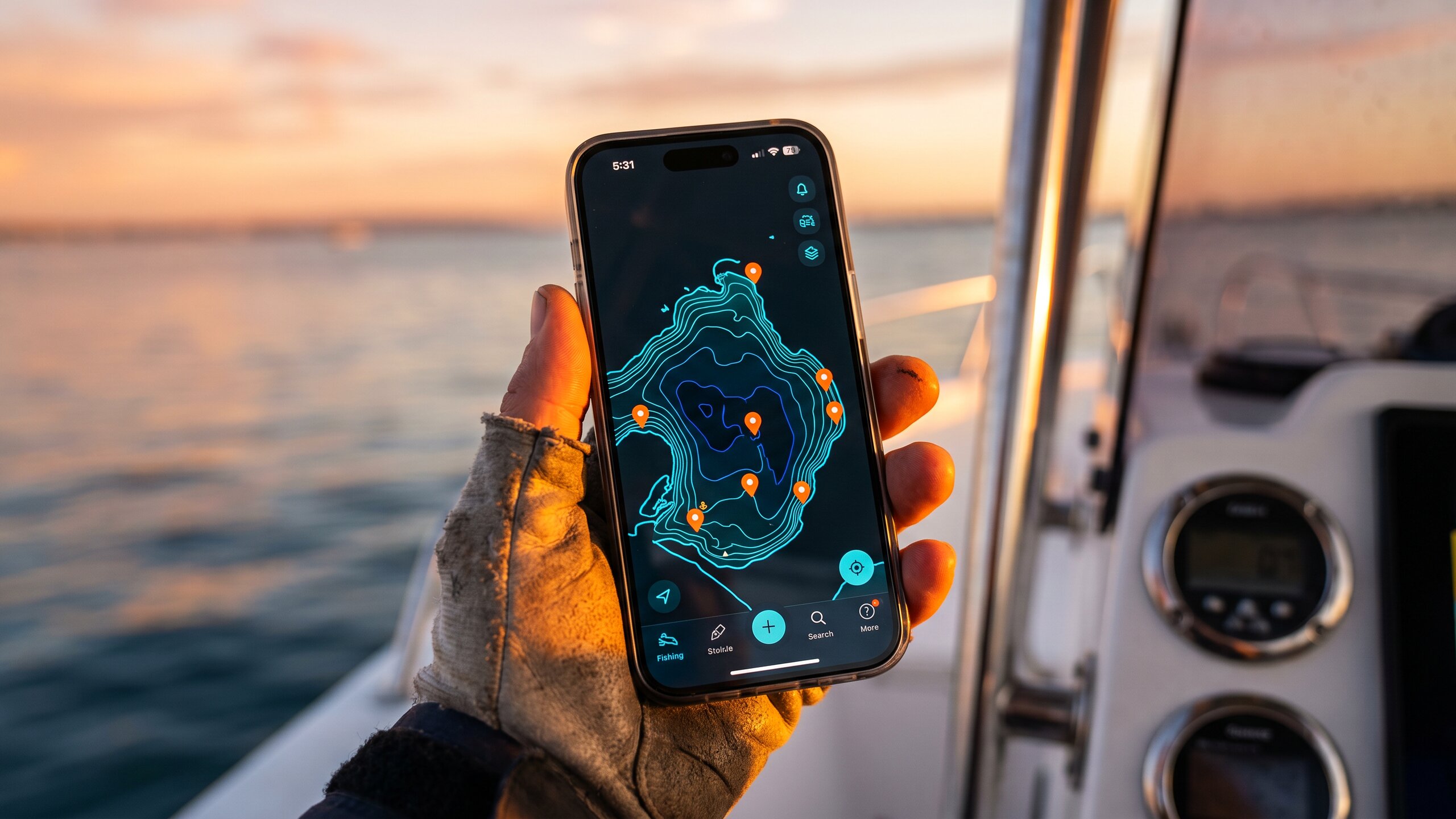
A view that shows the seabed

Most fishing apps show a road map with water on top. BayCast shows you the seabed itself — depth contours, drop-offs, holes, channels and reef edges for both bays. Built from public-domain AusSeabed bathymetry — the maps are free for everyone, the tool is what makes them useful.

The forecast on one screen

Wind, tide, barometer, bite times, even fuel range. The stuff you actually need before a session, not 14 pages of generic Australia-wide weather.

Catch diary with photos

Log a catch in 10 seconds. Take a photo. Done. Your sessions, your fish, your patterns — yours alone, on your phone.

Trophies for real captures

Eleven trophies. Snapper Slam. Whiting King. Squid Specialist. We trust your numbers — but the photo has to be from the same day. Old phone-roll fish can't unlock new trophies.

Reports feed, no Facebook circus

A clean place to share. Anglers post bite reports — but it's totally up to them what they share. No likes, no algorithm, no randoms arguing in the comments.

Safety, built in

Man Overboard pin in one tap. Emergency numbers one tap away. Heads-up when you're near a known dangerous bar. The stuff that matters when it matters.

The chart

A chart that actually shows the bays

Clean, fast, no junk on top. Built around what local anglers need to see, not what looks pretty in a brochure.

BayCast fishing app showing Port Phillip Bay bathymetry on a phone

Bathymetry both bays

Depth contours for Port Phillip and Western Port. The holes, the channels, the reef edges, the drop-offs. The structure that holds fish — same info the pros use, just easier to read.

  • Full coverage of both bays
  • Vicmap Relief overlay
  • Smooth on phone, tablet and desktop
  • Works offline once loaded
Aerial view of Port Phillip Bay at sunrise

Public marks tidied up

Every spot already on Google, the DPI website, fishing forums, public Facebook groups, magazine articles — pulled together so you've got them in one place. No bouncing between twenty tabs to find what's already known.

  • Public reefs, ramps, channels and structure
  • Sourced from publicly available info
  • Tidied, named and put on one chart
  • Your private spots stay private — yours alone
Fishing boat on Port Phillip Bay near Geelong

Layers you control

Wind. Tide. Satellite. Contours. Pick what you want, hide what you don't. The map should help you find fish, not bury you in icons.

  • Toggle each layer on or off
  • Fast on older phones
  • Satellite view for finding weed beds and reef patches
  • Saved settings between sessions
The forecast

Everything you need before a session

Not 14 pages of weather data. The stuff you actually look at on the way to the boat.

Wind

Speed, direction, how it changes through the day. The single most important number for the bays — front and centre.

Tide

High, low, when it turns, how big the run is. Charts you can read at a glance instead of squinting at numbers.

Barometer

Going up, going down, holding steady. The one most apps hide. Snapper anglers know why this matters.

Bite times

Solunar best windows for the day. Plain visual bars, no astrology, no nonsense.

Range

How far you can go on the fuel you've got, before you have to head back. Saves the day-trip from turning into a tow-trip.

Fuel cost

Auto-updates from the official ACCC weekly fuel report. So you know what a session is actually costing you in petrol.

Catch diary

Your fishing diary, on your phone

Not in your head, not in a notebook in the bin of the boat. Searchable, dated, with photos.

King George Whiting catch logged in BayCast

Log a catch in 10 seconds

Species, size, time, photo. That's it. The diary writes itself as you fish.

  • Species and size you fill in — we trust your numbers
  • Photos saved on your phone
  • Trip log shows every session, every catch
  • Search by species, date or month
  • Yours alone — nobody sees it unless you choose to share
Trophies

Trophies for real captures

Eleven of them. Each one unlocks when you actually catch the fish. Honest cabinet, fair to everyone.

You fill in the numbers

We trust your size and species. We don't measure your fish. You're an adult — log it honestly.

Photo from the same day

The photo's file date has to match. On the boat, at the ramp, back at home — anytime that day. Old phone-roll photos can't unlock new trophies.

Bag trophies, any 24 hours

Some trophies need a few good fish in a row. Any 24-hour window counts — no need to start a "trip" first.

Fresh slate each year

New year, new cabinet. Old years are kept, not deleted. Every January you start clean.

Auto-shared (only if you want)

Unlock a trophy and BayCast can drop a short note in the reports feed. No GPS, no spot leak — just the fish and the trophy.

Eleven trophies at launch

Snapper Slam, Whiting King, Squid Specialist, Calamari Hunter, and more. We add them as the seasons turn.

Reports feed

A clean place to share — without the Facebook circus

BayCast gives anglers a platform. Share whatever you want. Or share nothing. It's totally up to you.

Some anglers post "bite's on at sunrise" and that's it. Some share more. Some share nothing for months and just read what others post. Your spots stay your spots — we never share or sell anyone's location.

No likes-chasing. No algorithm deciding what you see. No randoms arguing in the comments. We built the room. You decide what to say in it.

It's a platform for sharing without the bullshit. That's it.

The species you actually catch

Built for what's in our bays

Snapper King George Whiting Squid / Calamari Gummy Shark Mulloway Yellowtail Kingfish Flathead Australian Salmon Garfish Silver Trevally Pinky Snapper Elephant Fish + more
"I just want a platform without all the Facebook bullshit. We built the room. You decide what to say in it."
— Brett Reed · Reedy's Rigs
From Reedy's Rigs

Snapper Port Phillip Bay – 1989 Golden Era

Rare footage from when the bay's old reds were everyone's secret. The fish are still there. Only the tools have changed.

BayCast · Reedy's Rigs

Get the app this video was made for

BayCast — bathymetry, wind, tide, bite times. Built by Reedy's, for Port Phillip & Western Port.

Sign up free
Reedy's Rigs · Est. 2008

Built by anglers who actually fish, not by AI

Reedy's Rigs is one of Australia's best-known tackle brands. Every rig is designed and tested by Brett Reed on Port Phillip and Western Port before it ever ships to a shelf.

BayCast is the app Brett built for himself — and now for the 70,000+ anglers who already follow Reedy's Rigs across Facebook and YouTube. Built on real fishing results, not theory. Not by AI.

Reedy's Rigs Sign up free
Brett Reed of Reedy's Rigs, Melbourne, with a bag of King George Whiting from Port Phillip Bay
Pricing

Get BayCast Pro

Free version handles the day-to-day. Pro unlocks the working tools — bite forecast, range to spot, fuel cost, measuring, transducer coverage, trophies. Cancel any time.

Monthly

$9.99per month · AUD
  • Everything in Pro
  • Cancel any time
  • One subscription — phone, tablet, desktop
Get Pro monthly

Billed monthly through Stripe. Secure checkout.

Free

$0forever
  • Bathymetry chart for both bays
  • Wind, tide, barometer
  • Catch diary, photos, public marks
  • Reports feed
Sign up free

Got an invite code from Reedy's? Open the app, sign in, and paste it in Settings — it unlocks Pro features.

All prices in AUD. Powered by Stripe — we never see your card. Cancel any time from your account.

Local fishing guides

Free guides for Port Phillip Bay & Western Port

Honest, locally-written guides for the species and ramps you'll actually fish. No fluff, no affiliate links, no rehashed Wikipedia. Written by Reedy's Rigs in Melbourne — the Reedy's Rigs team.

FAQ

Quick answers

Is BayCast live?
Yes. The app's live in any modern browser at baycast.com.au/app — sign up free and have a look.
Does it cost anything?
There's a free version that handles most day-to-day fishing — chart, wind, tide, diary, public marks, reports feed. Pro is $9.99/month or $89/year (use code EARLY40 at checkout to drop the yearly from $129 to $89). Pro unlocks bite forecast, range to spot, fuel cost, measuring tools, transducer coverage and trophies. See pricing.
I got an invite code from Reedy's — what do I do?
Open the app, sign in with your email, then paste the code in Settings. It unlocks Pro features on your account. One code per person.
Does it record or share my private spots?
Your diary is yours. Nothing is shared unless you choose to share it. We do bundle publicly known marks — spots already on Google, fishing forums, the DPI website — so you've got them tidied in one place. We never share or sell anyone's private locations.
Will it work without signal out on the water?
Yes — chart, marks and diary work offline once loaded. Live wind and tide need a connection.
Does it have an AI / voice thing?
We're testing one. Not promising anything till it's right.
Phone, tablet or desktop?
All three. BayCast runs in any modern browser — iPhone, Android, iPad or desktop. Install it to your home screen for one-tap access.
Which bays does it cover?
Port Phillip Bay and Western Port. More Victorian regions are on the way.
Why "BayCast"?
Built for the bays. Cast a line. Simple.
Who built it?
Brett Reed and the team at Reedy's Rigs in Melbourne. Reedy's has been running since 2008. The app started because the existing apps were generic worldwide tools that didn't fit Port Phillip Bay or Western Port.
How do I send GPS marks to my Lowrance, Garmin or Humminbird?
Drop a pin anywhere on the chart. BayCast shows the spot in three formats at once: DDM (Lowrance/Garmin/Humminbird), decimal degrees (Google/phone), plus more formats on tap. One-tap copy, paste straight into your plotter. Save it to My Marks, share it, or hit Navigate for ramp-to-spot distance and fuel cost.
When is snapper season in Port Phillip Bay and Western Port?
Big snapper move into both bays from October through January, with the peak run in November and December. Smaller pinkies stay year-round. Full breakdown on the Snapper guide. BayCast shows live barometer, bite times and tide — the three things that decide whether you launch.
Do I have to find my own fishing spots?
No. BayCast comes with hundreds of starter spots pre-loaded across Port Phillip Bay and Western Port. Tap any pin to see what people have caught there. You're never staring at an empty map. As you fish more, drop your own marks and build a private list only you can see.
Where can I fish in Port Phillip Bay and Western Port?
BayCast bundles publicly known marks for snapper, King George whiting, squid, gummy and elephant fish across both bays. We have local guides for snapper, King George whiting, squid, Western Port, and a full boat ramps page with wind protection, fees and ramp camera links.
Does BayCast work on iPhone, Android, iPad and desktop?
All four. BayCast runs in any modern browser with no app store install — just go to baycast.com.au/app and sign up free. Add it to your home screen for one-tap launch. The desktop and iPad versions show the 3D bathymetry chart at full size; phones get the same data, optimised for one hand on a rocking deck.
Is there a Port Phillip Bay or Western Port fishing report?
Yes — the Reports feed shows recent local catches with species, location, bait/lure and conditions. Post your own with one tap from the catch diary. No Facebook drama, no spam. Just what's biting where, right now.

Have a look around.

Open the free app. Like what you see, grab Pro for $9.99/month or $89/year with code EARLY40.